Three Pines National Forest, Tasmania
Three Pines National Forest covers 4,800 hectares of mixed eucalyptus and native pine woodland forty kilometres north-west of Hobart, gazetted in 1954 following decades of logging and Dr Harold Penberthy's meticulous botanical advocacy. A generation of southern Tasmanians grew up walking its Ridge Loop and Banksia Loop tracks on school excursions and family weekends — until a Sunday afternoon in March 2016 gave the forest a second, darker reputation that no amount of conservation signage could soften.
The Land Before the Name
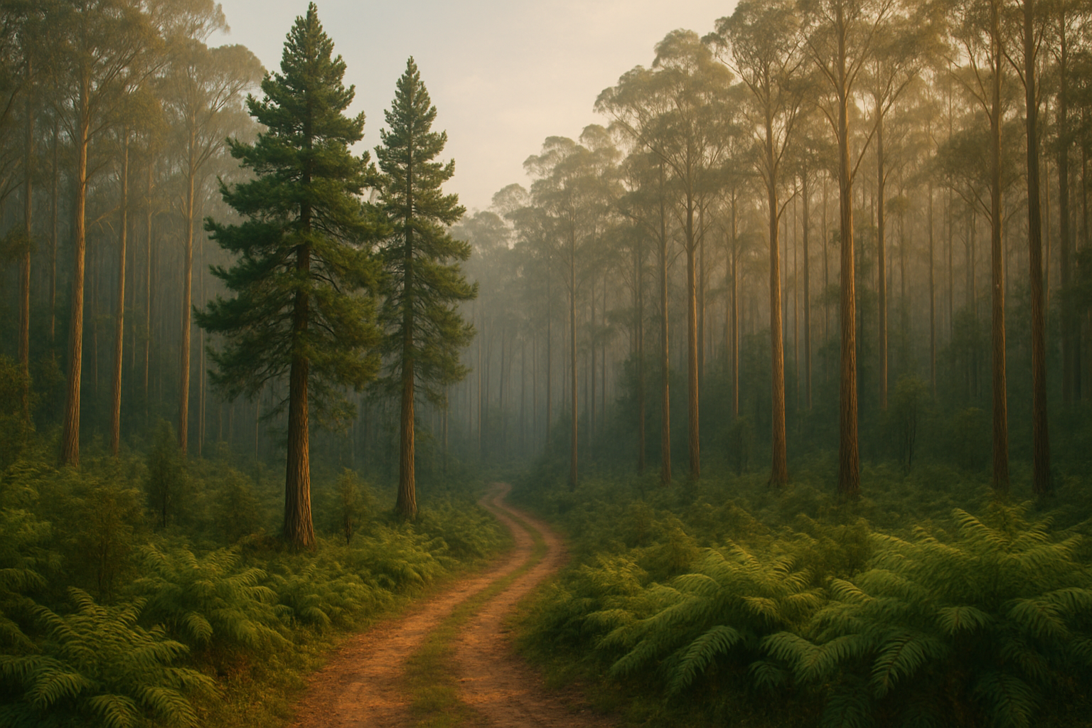
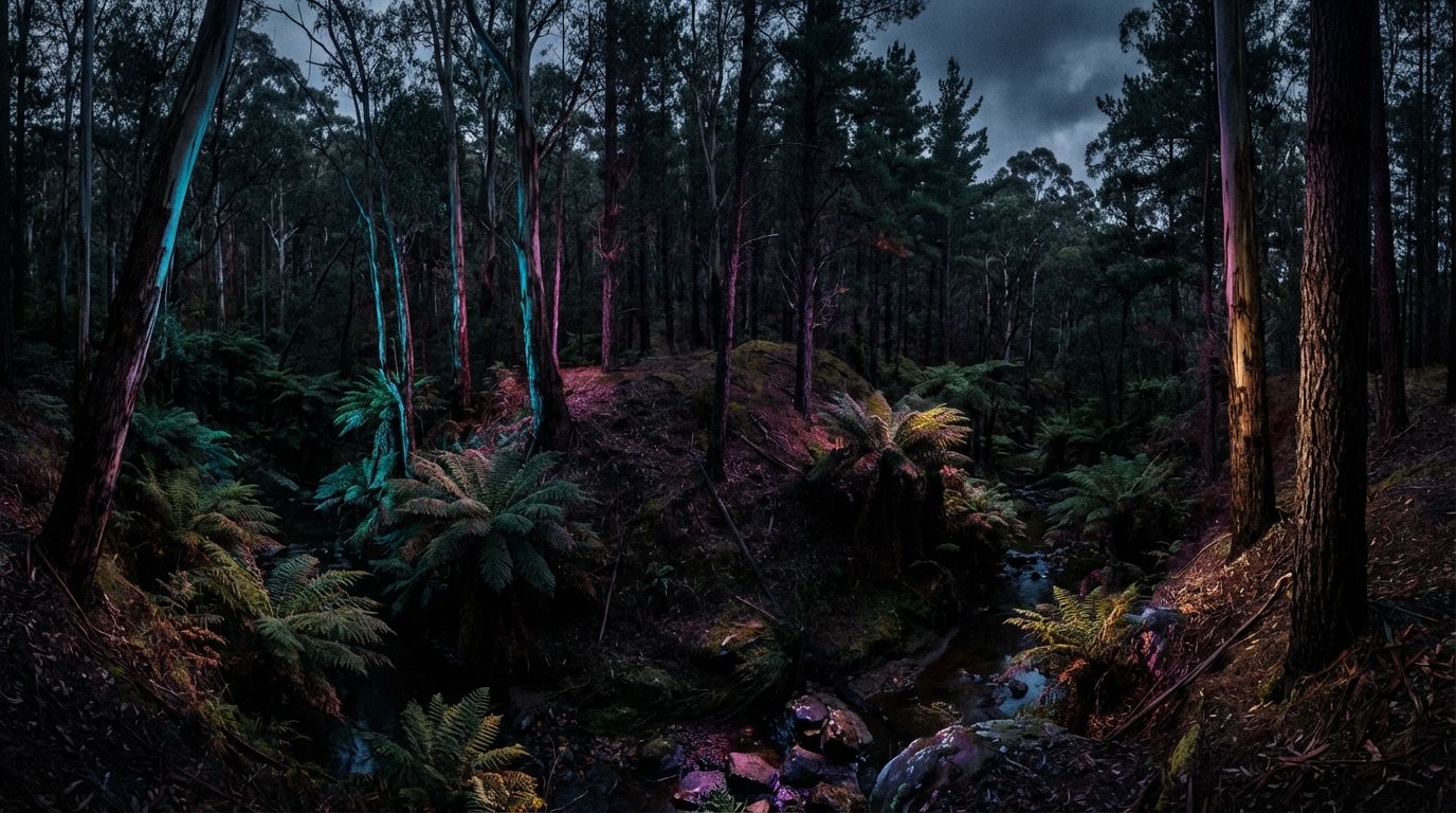
Three Pines National Forest occupies approximately 4,800 hectares of mixed eucalyptus and native pine woodland forty kilometres north-west of Hobart, within a transitional zone between the Derwent Valley's settled lowland and the foothills that rise toward the Central Highlands. The terrain is varied without being dramatic — undulating ridges separating damp gullies thick with tree ferns, occasional open clearings where sunlight breaks through the canopy in columns that shift with the season, and a network of creeks whose flow depends entirely on whether it has rained in the preceding fortnight.
It is not wilderness in the way Tasmania's south-west is wilderness, nor parkland in the way a city reserve is parkland. It is something between — managed enough to walk through comfortably, wild enough that a person who left the formed tracks could be genuinely lost within an hour. The forest's elevation ranges from approximately 180 metres along the creek flats to 460 metres on the northern ridge, a gradient that produces noticeable shifts in vegetation within relatively short distances. Wet sclerophyll forest dominates the gullies, giving way to drier eucalyptus woodland on the ridges and, in the sheltered pockets where moisture and shade converge, remnant stands of the native conifers that gave the place its name.
The soil is predominantly dolerite-derived clay — heavy, slow to drain, and prone to becoming treacherously slippery on slopes after rain. Trail maintenance in Three Pines has always been a battle against gravity, water, and the tendency of Tasmanian clay to transform a gentle gradient into a mud chute overnight.
Palawa Country
The forest sits within the traditional lands of the South-East Nation of the Palawa people, whose connection to this country extends back thousands of years. Archaeological surveys conducted in the 1970s and again in the early 2000s identified several stone artefact scatters along the river margins, including a significant concentration near the junction of the two main creek systems where the terrain flattens into a natural gathering space.
Shell middens along the forest's southern boundary indicate seasonal camps, and the presence of both coastal and freshwater shell species suggests the area served as a transit corridor between the Derwent estuary and the highland hunting grounds. Oral histories collected from Palawa elders, including accounts recorded by the Tasmanian Aboriginal Centre in the 1980s, speak of the forest as a place tied to ancestral narratives about the creation of local waterways and the movements of marsupial species whose presence shaped the country long before European feet broke its soil.
The relationship between the forest's European management and its Indigenous heritage has been, like most such relationships in Tasmania, complicated by decades of inadequate consultation and belated recognition. A formal cultural heritage assessment was not completed until 1998, forty-four years after the forest was gazetted. The interpretive shelter built in 2003 includes a Palawa heritage display developed in collaboration with the Tasmanian Aboriginal Centre, though community elders have noted that the display addresses what visitors might find interesting rather than what the Palawa community considers important — a distinction that matters more than its diplomatic phrasing suggests.
Three Pines That Became a Name
The forest takes its name from three unusually large pencil pines — Athrotaxis cupressoides — that once stood on a rocky knoll near the main southern trail. The species is ancient, a Gondwanan relic whose lineage predates the flowering plants that now dominate the forest floor. Pencil pines grow with geological patience, adding barely a millimetre of trunk diameter per year, and the Three Pines specimens were estimated at over eight hundred years old when the 1967 bushfires destroyed them.
Their charred stumps remain on the knoll, blackened columns rising barely a metre from the ground. Visitors who encounter them without warning sometimes mistake them for the remnants of fence posts before reading the interpretive sign that explains what stood there for eight centuries and what took an afternoon to destroy.
The 1967 fires — which ravaged much of south-eastern Tasmania on Black Tuesday, 7 February — burned approximately 1,200 hectares of the forest's eastern flank. The pencil pines, standing on their exposed knoll without the moisture protection that sheltered specimens in the gullies below, had no defence against a firestorm that generated its own wind. Unlike eucalyptus, which has evolved to regenerate from fire through epicormic budding and lignotuber resprouting, Athrotaxis species possess no such adaptation. When they burn, they die. When they die, nothing replaces them within a human lifetime.
The stumps have become the forest's most photographed feature, which says something about what people find compelling — not the living forest around them, but the evidence of what was lost.
Axes, Sawmills, and Neglect
European exploitation of the area began in the late 1820s, when small-scale sawmills were established along the river flats to supply timber for Hobart's expanding settlement. The tall, straight-trunked Eucalyptus obliqua was favoured for ship masts and building beams, while native pine — particularly Lagarostrobos franklinii, the Huon pine, found in small stands along the creek margins — was prized for its durability in applications where rot resistance mattered more than aesthetics.
The earliest recorded sawmill, operated by a man named Craddock whose first name does not survive in the records, was established on the main creek flat around 1828 and operated intermittently until the 1850s. A second mill, owned by the Harwood brothers of Perth, operated from approximately 1845 to 1872 on the forest's western edge, supplying railway sleepers and bridge timbers to the colony's expanding infrastructure. The Harwood operation was the more significant of the two — at its peak employing twelve men and producing enough sawn timber to require a dedicated bullock track to the New Norfolk road.
Logging continued intermittently through the remainder of the nineteenth century, driven by demand rather than any coherent management plan. By the 1890s, much of the easily accessible timber had been removed. The larger eucalypts that had dominated the ridgelines were gone, replaced by regrowth that would take a century to reach comparable dimensions.
The area entered a period of relative neglect that lasted roughly sixty years — used sporadically for grazing, for hunting, for the kind of informal occupation that occurs in places nobody is paying sufficient attention to regulate. A few farming families ran cattle through the forest's southern margins. Rabbit trappers worked the clearings. The odd prospector tested creek gravels for alluvial tin without finding enough to justify the effort. The forest, left largely to itself, began the slow process of recovering from what had been done to it.
Penberthy's Inventory
The forest's formal protection came in 1954, when it was gazetted as a national forest following sustained advocacy by the Tasmanian Bushwalking Association and Dr Harold Penberthy, a University of Tasmania botanist who had spent two decades documenting the remaining old-growth stands and arguing that their scientific value exceeded their commercial worth.
Penberthy first visited Three Pines in 1932 as a postgraduate student conducting vegetation surveys for his doctoral thesis on wet sclerophyll community structure. He returned repeatedly over the following years, building a body of fieldwork that few other Tasmanian botanists could match for thoroughness. His published surveys identified forty-seven tree species, over a hundred understorey plants, and fourteen species of moss within the forest's boundaries. He mapped the distribution of each with the kind of precision that made his field notebooks, now held in the University of Tasmania's Special Collections, valuable reference documents seventy years after they were written.
His case to the state government rested not on sentiment but on inventory — the forest was too ecologically dense and too scientifically interesting to justify reducing it to stumps and sawdust. The gazetting was not achieved without opposition. Timber interests argued that the forest's regrowth eucalyptus represented a harvestable resource, and the Derwent Valley municipal council raised concerns about removing productive land from potential development. Penberthy's response, delivered in characteristically measured prose to a parliamentary committee in September 1953, noted that the forest had already been logged of its most valuable timber and that what remained was worth more standing than felled. The committee agreed, narrowly.
Early management focused on fire control, trail creation, and reforestation programmes in areas where logging had been heaviest. Selective harvesting was controversially permitted in the outer buffer zones until the late 1970s, a compromise that satisfied nobody — conservationists considered it an ongoing violation of the forest's protected status, while timber interests considered the permitted volumes too small to be commercially viable. The compromise was eventually abandoned not because either side prevailed but because the trees in the buffer zones were not worth the cost of extracting them.
The Lindridge Sisters and the Walking Tracks
From the 1960s onward, Three Pines became popular with bushwalkers, birdwatchers, and school excursion groups drawn by the forest's accessibility — close enough to Hobart for a day trip, varied enough in terrain to offer genuine walking rather than a suburban stroll, and sufficiently well-signposted that families with young children could manage the easier circuits without anxiety.
The Ridge Loop, a 4.2-kilometre circuit following the southern ridgeline with views across the Derwent Valley, was the first formally constructed track, completed in 1963 with funding from the Tasmanian government's nascent recreation infrastructure programme. The Riverbend Walk, a 5.8-kilometre out-and-back trail following the main creek through wet forest to a small waterfall, followed in 1971. The Banksia Loop, a gentler 3.6-kilometre family-friendly circuit through dry woodland featuring seasonal banksia displays, was added in 1985.
The tracks owed much of their development and maintenance to the Friends of Three Pines, a volunteer conservation group founded in 1978 by sisters Moira and Kathleen Lindridge. The Lindridge sisters had grown up in the Derwent Valley and regarded the forest with the proprietary affection of people who consider a landscape theirs by virtue of having walked it since childhood.
Moira, the elder by three years, handled the organisation's administration and government liaison with a bluntness that civil servants found either refreshing or exhausting depending on their temperament. Kathleen, quieter and more botanically inclined, led the guided walks and wildflower identification programmes that became the group's public face. Between them, they raised funds for track maintenance, published seasonal wildflower guides that went through seven editions, and campaigned — with mixed success — against proposals to extend the adjacent forestry coupe boundaries into the national forest's buffer zones.
The Friends of Three Pines at its peak maintained a membership of approximately 180, drawn predominantly from Hobart's educated middle class — retired teachers, public servants, university staff, and the kind of people who own multiple pairs of gaiters and hold opinions about trail surface materials. Their working bees, held on the first Saturday of each month from March to November, kept the tracks in better condition than the Parks and Wildlife Service's maintenance budget could have achieved alone.
By the early 2000s, Three Pines was receiving an estimated twelve thousand visitors annually. The figure placed increasing pressure on sensitive ecosystems, particularly the wetland sections along the Riverbend Walk where foot traffic was compacting soil and damaging root systems. Boardwalks were installed through the worst-affected areas in 2004, and several informal trails — tracks created by walkers who preferred convenience to conservation — were closed and rehabilitated with native plantings.
Infrastructure and Isolation
The forest's infrastructure by 2016 comprised the three formed walking tracks totalling approximately fourteen kilometres, two picnic shelters near the southern car park, composting toilets at the main trailhead and the Riverbend junction, and the interpretive shelter built in 2003.
The car park accommodated approximately forty vehicles, though on popular weekends overflow parking extended along the access road's gravel shoulders. A bollard gate at the car park entrance was locked at dusk by whichever Parks and Wildlife ranger happened to be rostered for the Derwent Valley circuit that week — a system that worked adequately when rangers remembered and failed when they did not.
Mobile phone reception was unreliable throughout the forest — adequate near the car park and along the southern ridgeline where the terrain opened toward the valley, degrading to intermittent on the Banksia Loop, and functionally nonexistent in the gullies and the forest's northern reaches where the ridge blocked line of sight to the nearest transmission tower. An emergency marker system installed in 2011 placed numbered posts at 500-metre intervals along each track, allowing callers to describe their location to emergency services — provided they could get a signal to make the call.
The nearest staffed ranger station was at the Derwent Valley Parks and Wildlife office, twenty-five minutes' drive south along a road that was sealed for the first fifteen kilometres and gravel for the remainder. The nearest police station was at New Norfolk, approximately thirty minutes from the car park. The nearest hospital was the Royal Hobart, over an hour's drive in good conditions.
Three Pines operated, in practical terms, on the assumption that its visitors were sensible adults who could read a trail map and carry sufficient water, and that emergencies would be rare enough to manage through the standard process of someone driving to phone range and calling triple zero. The assumption was not unreasonable. In sixty-two years of operation as a national forest, Three Pines had recorded three serious bushwalking injuries requiring helicopter evacuation, one death from cardiac arrest on the Ridge Loop in 2009, and no incidents involving criminal activity more serious than vandalism to the composting toilets.
The assumption held for sixty-two years. On 27 March 2016, it did not.
Conservation at the Edges
The forest faces ongoing conservation pressures characteristic of Tasmania's protected areas. Climate change-driven bushfire risk has placed Athrotaxis stands across the state on ecological watch lists, and the 2016 fires in the Tasmanian Wilderness World Heritage Area — which destroyed over ten thousand hectares of ancient pencil pine and King Billy pine forest — served as a grim reminder that what happened on the knoll in 1967 could happen again on a vastly larger scale.
Invasive species present persistent challenges. Gorse, introduced in the nineteenth century as hedging material and now one of Tasmania's most aggressive environmental weeds, encroaches along the forest's southern boundary where cleared farmland meets the conservation zone. Feral cats, whose impact on native small mammals and ground-nesting birds is well documented but whose management requires resources that compete with every other conservation priority, maintain a population within the forest that trapping programmes have reduced but not eliminated.
Boundary management remains a contentious issue. The forestry coupes adjacent to the forest's western edge have been the subject of recurring disputes between timber interests, environmental groups, and local government — disputes whose arguments have barely shifted in four decades even as the participants have changed. The core conservation area remains well protected under state and federal legislation. What happens at its edges — as is so often the case with Tasmanian conservation — depends on which government holds office and which lobby group has its ear.
The Forest People Remember
Three Pines is not the largest, the most spectacular, or the most ecologically significant of Tasmania's protected forests. It lacks the grandeur of the Tarkine, the ancient mystique of the Styx Valley's giant trees, or the World Heritage status that protects the south-west wilderness from everything except climate change.
What it has, instead, is familiarity. A generation of southern Tasmanians grew up walking through Three Pines on school excursions and family weekends. They ate sandwiches at the picnic shelters, learned the difference between a black peppermint and a white peppermint from Kathleen Lindridge's wildflower guides, and stood on the knoll looking at charred stumps while a teacher explained what fire does to things that cannot run from it.
The forest's name, for most of those people, carried associations of packed lunches and tired legs and thermoses of tea in the car park afterwards. Until a Sunday afternoon in March 2016 gave it a second, darker reputation that no amount of conservation signage could soften.