Eton, Berkshire, England
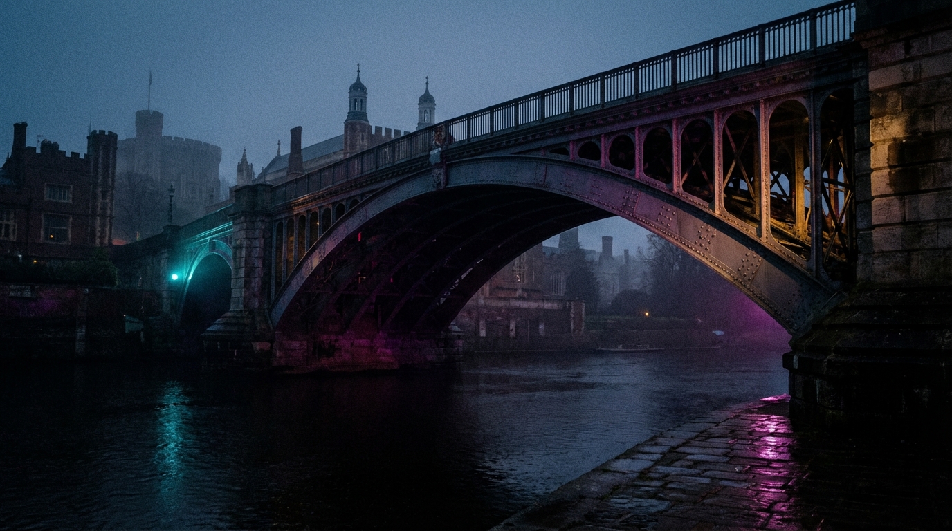
Eton is a small town on the north bank of the River Thames in Berkshire, connected to Windsor by an iron bridge that has carried traffic across the river since 1824. The settlement is recorded in the Domesday Book as Ettone, held by the manor of Queen Edith before the Conquest. Since 1440, when Henry VI founded his college on the meadows north of Barnes Pool, the town's identity has been inseparable from the institution it hosts.
Before the College: Ettone in the Domesday Book
The name Eton derives from the Old English Ēa-tūn, meaning river-town, and the settlement's existence has always been defined by its position on the north bank of the Thames, directly opposite the royal fortress at Windsor. Before the Norman Conquest, the manor of Eton was held by Queen Edith, wife of Edward the Confessor. By 1086, the Domesday survey recorded it under the lordship of Walter son of Other — ancestor of the family that would take the name Windsor — assessed at twelve hides and valued at six pounds, with two mills worth twenty shillings and fisheries yielding a thousand eels annually. Walter held the offices of warden of the forests in Berkshire and castellan of Windsor Castle, and the settlement he governed was a modest riverside hamlet, its chief significance the road from London to Windsor that passed through its pasture meadows and across the bridge.
The Bridge
There has been a bridge connecting Eton and Windsor since at least the twelfth century. By 1172, a farmer named Osbert de Bray was earning over four pounds a year from tolls levied on vessels passing beneath the timber crossing. In 1242, permission was granted to fell oak trees in Windsor Forest for the construction of a new bridge, and over the following centuries the wooden structure was rebuilt repeatedly, battered by floods, collisions with laden barges, and the slow attrition of a tidal river. By 1819, the bridge had deteriorated beyond repair, and an Act of Parliament the following year authorised the borrowing of sixteen thousand pounds to replace it.
The architect Charles Hollis designed the new bridge — three cast-iron arches resting on granite piers, the central span measuring fifty-five feet, the whole structure two hundred feet long and twenty-six feet wide. The foundation stone was laid on 10 July 1822 by Frederick, Duke of York, with Masonic ceremonies that drew crowds of strangers to the town. Construction was plagued by setbacks: a barge collided with the works and sank, cast-iron ribs shipped from Wales were found defective and broke during unloading, and a labourer working on the piling was crushed to death by the descending hammer. The bridge finally opened on 1 June 1824, and it remains the oldest iron arch bridge still standing over the Thames. It carried horse-drawn and motorised traffic for nearly a century and a half — tolls were not abolished until 1898 — before structural cracks discovered in 1970 closed it to all vehicles. It has served as a pedestrian and cycle bridge ever since, refurbished in 2002 with Yorkstone paving, and is Grade II listed.
The College and the Town
Until the mid-fifteenth century, Eton remained a place of small importance save as a thoroughfare to Windsor. That changed irrevocably in 1440, when Henry VI chose the meadows north of Barnes Pool — a backwater of the Thames crossed by a bridge maintained under a trust dating to at least 1592, when Elizabeth I warranted the Baldwin Bridge Trust as one of the oldest charities in England — as the site for his new foundation, The King's College of Our Lady of Eton beside Windsor. Workmen flooded into the hamlet. The land immediately surrounding it was granted to the college, which effectively halted further independent growth. The new chapel drew pilgrims, and inns sprang up along the High Street to serve them. Henry granted the college the right to hold fairs on its grounds, and from that point forward the fortunes of the town and the institution became inseparable.
The relationship was symbiotic but unequal. The college acquired virtually all the land north of Barnes Pool Bridge, and by the early twentieth century observers noted that Eton was almost entirely commercial and non-residential — its shops, inns, tailors, and tea rooms existing to serve the needs of the boys and masters in residence. Ancient Lammas rights, dating from at least the seventh century, preserved the open meadows of South Field, Brocas, and Eton Common from enclosure, preventing the residential development that might have given the town an identity independent of its famous school. These same rights delayed the arrival of the railway, though Brunel's Windsor Railway Bridge — its design required to keep the Thames entirely unobstructed, a condition imposed by the Provost of Eton — was completed in 1849, connecting the town to Slough and thence to London.
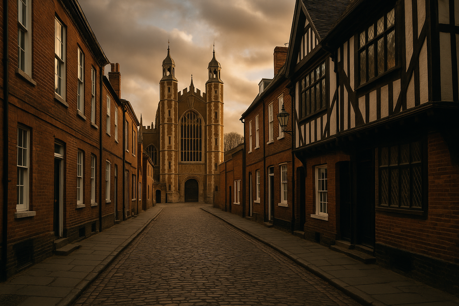
The High Street
The High Street of Eton follows the ancient road from London to Windsor, and royal processions passed along it for centuries. The most famous was the funeral cortège of Jane Seymour, third wife of Henry VIII, in 1537, making its way to burial at St George's Chapel in Windsor Castle. The oldest surviving building is a fifteenth-century timber-framed structure now known as the Cockpit, mentioned in documents from 1465 when it was owned by Thomas Jourdelay, an early benefactor of the college. In 1508 it was purchased by St George's College across the river, and by the seventeenth century it served as a popular inn called the Adam and Eve. An outhouse behind it, once used as an abattoir, retains its original knuckle-bone floor — mistakenly identified in the twentieth century as a medieval cockpit, a misattribution that gave the building its enduring name.
Further along the street stands the Crown and Cushion Inn, built in 1600 and operating as an inn since 1753, and the Christopher Inn, an eighteenth-century coaching house of which Horace Walpole wrote in 1746, "Lord, how great I used to think anybody just landed at the Christopher." Turks Head Court preserves a passage through a timber-framed building leading to a row of whitewashed and red-brick cottages along a narrow lane. Beside the Cockpit, a red letterbox dating from 1854 is one of the earliest of the familiar pillar-box designs still in use in England.
The Parish Church and Porny's School
When the College Chapel was completed in the late fifteenth century, the original parish church was pulled down, and for more than two hundred and fifty years the chapel served the spiritual needs of both the college and the wider parish. In 1769, a chapel of ease was built by the Reverend William Hetherington, a fellow of Eton, to provide for the growing population. This in turn was replaced by the present Church of St John the Evangelist, whose foundation stone was laid on 21 October 1852 by Prince Albert. Consecrated in 1854, the stone building in the Early Decorated style originally featured a tower and spire rising one hundred and sixty feet — a prominent landmark visible from the meadows and the railway — though the spire was removed in 1954 when it proved too heavy for the marshy ground on which the church was built. The east window was inserted in 1865 as a memorial to the Prince Consort, and in 1875 the formal connection between the parish and the college was dissolved, establishing St John's as the independent parish church.
The town's other educational institution, considerably more modest in ambition than its famous neighbour, owes its existence to Antoine Pyron du Martré — known in England as Mark Anthony Porny — who served as French Master at Eton College until his death in 1802. Under the terms of his will, the residue of his estate, approximately seven thousand pounds, was directed to the foundation of a charity school for the boys and girls of the parish. Porny's School was established in 1812 at 29 High Street, later relocating to its present site at 14 High Street. It continues today as Eton Porny Church of England First School, educating local children aged four to nine.
Brocas, Lammas, and the Meadows
The Brocas is a large meadow adjacent to the Thames, belonging to Eton College and forming part of the river's floodplain. Named after the Brocas family, who held it in the sixteenth century, it affords what is perhaps the finest view of Windsor Castle from any public ground — the slender buttresses of St George's Chapel giving delicate relief against the rugged walls of the Lower Bailey and the Curfew Tower. It is from the Brocas that the Procession of Boats departs on the Fourth of June, the college's annual celebration of George III's birthday, when rowing crews in old-fashioned wooden vessels process upriver in a spectacle that has drawn families and visitors for generations.
The open character of Eton's landscape — the meadows, the playing fields, the unbuilt stretches of common — is not accidental but the consequence of Lammas rights that have governed the use of the land since at least the seventh century. Under these ancient customs, the meadows are held in common for grazing between Lammas Day in August and Lady Day in March, and no individual may enclose or build upon them. This preservation of common land, together with the college's ownership of virtually all surrounding property, has given Eton an appearance of rural tranquillity that belies its proximity to London, Slough, and the suburban expansion of the Thames Valley. It is one of the few parishes in England where Lammas rights remain in active operation.
From Buckinghamshire to Berkshire
Eton was governed by a local board from 1849 and by an urban district council from 1894. For the whole of its recorded history until 1974, it lay within Buckinghamshire — an administrative fact that reflected the ancient county boundary along the Thames. The Local Government Act 1972 abolished the Eton Urban District Council and transferred the town to Berkshire, effective 1 April 1974, placing it within the newly created Royal Borough of Windsor and Maidenhead. A successor parish council, adopting the name Eton Town Council, was established at 102 High Street, with seven councillors for Eton and seven for Eton Wick. The transfer across the county boundary was a bureaucratic convenience that recognised what geography had always made obvious: that Eton's life was oriented not northward into the Buckinghamshire countryside but southward, across the bridge, toward Windsor and the castle that has shaped its existence for nearly a thousand years.