Beyoğlu, Istanbul, Turkey
Beyoğlu is an administrative district on the European side of Istanbul, occupying the hillside and ridge north of the Golden Horn between the Bosphorus waterfront and the commercial corridor of İstiklal Avenue. Historically known as Pera — the foreign quarter of Ottoman Constantinople — the district has served as Istanbul's centre of cosmopolitan culture, nightlife, and independent commerce since the nineteenth century, encompassing neighbourhoods including Galata, Cihangir, Tophane, and Taksim.
Geography and Boundaries
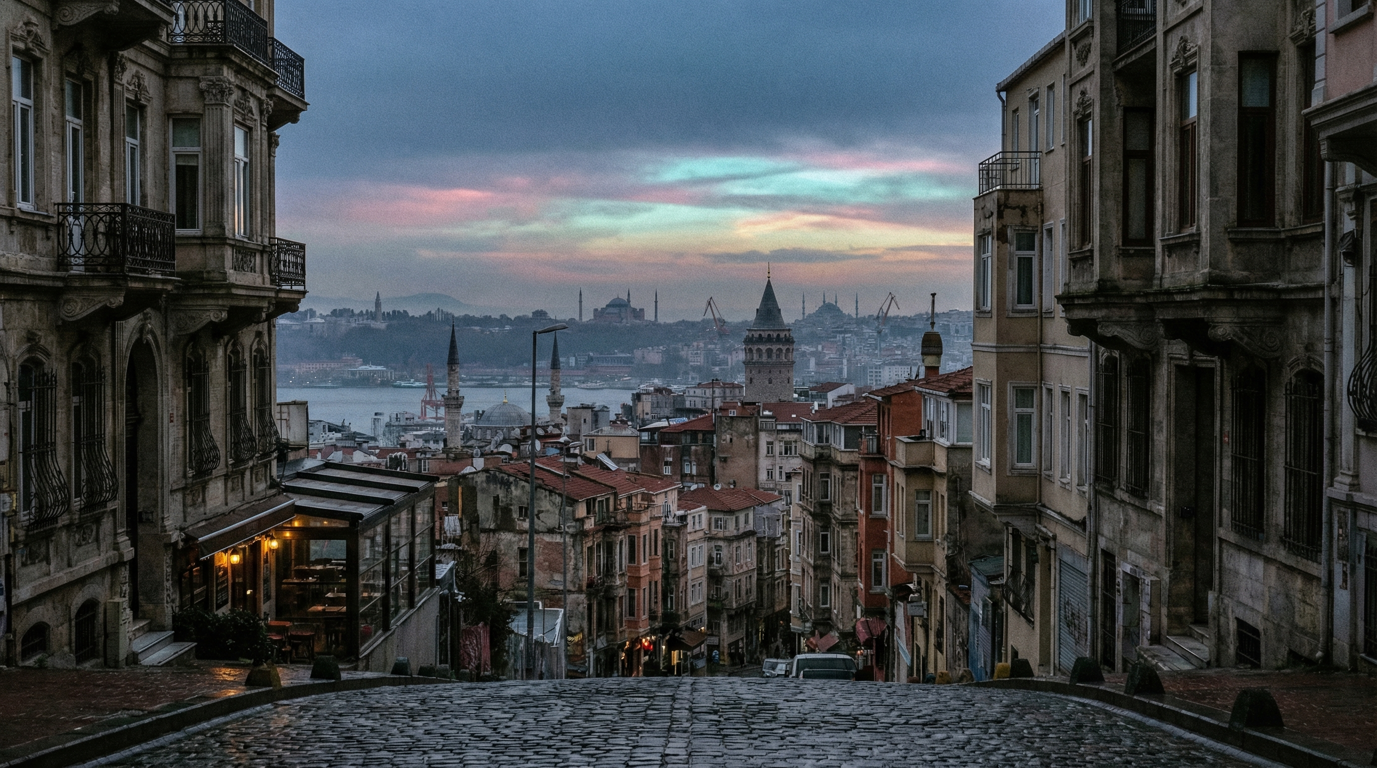
Beyoğlu occupied the elevated ground north of the Golden Horn on Istanbul's European side, its territory climbing from the waterfront districts of Karaköy and Tophane through the steep residential slopes of Cihangir and Galata to the ridge along which İstiklal Avenue ran between Tünel at its southern end and Taksim Square at its northern. The district's eastern boundary followed the Bosphorus shore from the ferry terminals at Karaköy northward through Fındıklı and Kabataş, whilst its western edge merged into the residential density of Şişhane and Kasımpaşa, where the hillside descended toward the Golden Horn's inner reaches.
The terrain was the district's defining physical characteristic. Beyoğlu was built on a hill, and the hill made itself felt in every aspect of daily existence — in the steep lanes that connected the waterfront to the ridge, in the staircases that substituted for streets where the gradient defeated conventional paving, in the calves of residents who walked its geography daily and the breathlessness of visitors who underestimated what a map's contour lines meant in practice. The elevation rewarded those who climbed it with Bosphorus views that appeared between buildings at unexpected intervals, framed by rooflines and minarets in compositions that the terrain had arranged without human intention.
Historical Development
The district's history predated its Turkish name. During the Byzantine and early Ottoman periods, the area north of the Golden Horn was known as Pera — from the Greek for "across" or "beyond" — designating the territory that lay across the inlet from Constantinople proper. The Genoese trading colony established on the Galata hill in the thirteenth century formed the district's earliest significant settlement, its fortified walls and commercial infrastructure creating a semi-autonomous enclave whose relationship with the city on the opposite shore was defined by commerce, competition, and the mutual tolerance that profitable trade encouraged.
The Ottoman conquest of 1453 incorporated Pera into the expanding city, but the district retained its character as the quarter where foreign and non-Muslim communities concentrated. European embassies established themselves along the Grande Rue de Péra — the thoroughfare that would become İstiklal Avenue — and the diplomatic presence attracted the commercial, cultural, and social infrastructure that foreign populations required: hotels, restaurants, churches, theatres, schools conducted in European languages, and the particular atmosphere of cosmopolitan sociability that characterised districts where multiple cultures coexisted in proximity without fully integrating.
The nineteenth century transformed Pera into something approaching a European city transplanted onto Ottoman soil. The architecture that lined İstiklal Avenue and its tributaries drew on Parisian, Viennese, and Italian precedents — apartment buildings with ornamental facades, commercial arcades with iron-and-glass roofing, the Pera Palace Hotel whose guest register would eventually include Agatha Christie, Atatürk, and the particular category of international traveller who required both comfort and proximity to intrigue. The nostalgic tram that ran along İstiklal — originally horse-drawn, later electrified, eventually restored as a heritage line — became the district's most recognisable symbol, its bell announcing arrivals at stops whose names traced the avenue's progression from Tünel to Taksim.
Greek, Armenian, Jewish, Levantine, and European communities maintained distinct institutional presences — churches, schools, hospitals, cultural organisations — whilst sharing the commercial spaces and residential streets that the district's density made communal rather than segregated. The cosmopolitanism was genuine if imperfect: communities that lived beside each other did not necessarily live with each other, and the social distances that ethnicity and religion maintained were as real as the physical proximity that the district's geography imposed.
The mid-twentieth century disrupted this arrangement. The Istanbul pogrom of 6–7 September 1955, directed primarily against the city's Greek population, damaged properties throughout Beyoğlu and accelerated a demographic shift that had been developing for decades. Non-Muslim populations diminished through emigration, their departure thinning the cosmopolitan character that had defined the district since the Ottoman period. Buildings that had housed multi-ethnic communities were subdivided, repurposed, or neglected. By the 1970s and 1980s, significant portions of Beyoğlu had deteriorated into a condition that the district's nineteenth-century architects would not have recognised — the grand facades crumbling, the commercial arcades declining, the atmosphere carrying a quality of diminishment that contrasted sharply with the district's self-image as Istanbul's most sophisticated quarter.
The Constituent Neighbourhoods
Beyoğlu's administrative boundaries encompassed dozens of distinct mahalles — neighbourhoods whose individual characters contributed to the district's overall texture without being reducible to it. The major constituent areas each maintained identities that reflected their particular geography, history, and the populations that had shaped them.
Galata occupied the hill's lower slopes above Karaköy, its medieval tower providing the landmark that oriented visitors and residents alike. The neighbourhood's Genoese foundations remained visible in fragments of stonework embedded in later construction, and its commercial character — antique dealers, instrument makers, the particular density of small enterprises that steep streets and old buildings accommodated — persisted through successive waves of demographic and economic change.
Cihangir clung to the hillside between the Tophane waterfront and the ridge, its steep residential streets offering Bosphorus views that had attracted artists, writers, and the broader creative class since the neighbourhood's bohemian revival in the 1990s. The Cihangir Mosque, commissioned by Sultan Süleyman the Magnificent in the 1550s, marked the neighbourhood's highest point.
Tophane occupied the waterfront zone where the hillside met the Bosphorus, its name deriving from the Ottoman cannon foundry that had once dominated the area. The neighbourhood's maritime and industrial heritage had given way to a transitional character — galleries, restaurants, and cultural venues occupying spaces that shipping offices and workshops had previously claimed.
Asmalımescit, tucked into the streets between İstiklal Avenue and the British Consulate, had developed as the district's nightlife centre — bars, restaurants, and music venues compressed into a few dense blocks whose evening energy contrasted sharply with the daytime quiet of streets that processed hangovers as efficiently as they generated them.
Çukurcuma, slightly south of İstiklal, maintained its identity as the antiques quarter — shops and dealers whose stock ranged from Ottoman-era furniture to mid-century European curiosities, the neighbourhood's name deriving from a sunken terrain feature that the surrounding streets descended into before climbing out the other side.
Taksim Square, at the district's northern end, served as Istanbul's symbolic political and social centre — the site of Republic Monument, the terminus of İstiklal Avenue's pedestrian flow, and the gathering point for demonstrations, celebrations, and the daily human traffic of a city whose European side funnelled through this space with a density that no urban planning could have anticipated or adequately managed.
İstiklal Avenue
The avenue that bisected Beyoğlu functioned as far more than a commercial thoroughfare. İstiklal Caddesi — Independence Avenue, named in the early Republic — ran approximately 1.4 kilometres from the Tünel funicular station at its southern end to Taksim Square at its northern, its pedestrianised surface carrying foot traffic that reached hundreds of thousands of people daily during peak periods.
The buildings lining the avenue constituted one of Istanbul's most concentrated collections of nineteenth-century European architecture — consulate buildings, commercial arcades, apartment blocks, theatres, churches, and the Pera Palace Hotel, whose facade projected the particular confidence of an era when Beyoğlu's ambition was to rival the boulevards of Paris and Vienna. The ground-floor commercial spaces housed an ecosystem that reflected the avenue's role as both destination and thoroughfare: international retail chains occupied the most prominent frontages, whilst independent shops, bookstores, record stores, cinemas, and the particular miscellany of small businesses that pedestrian traffic sustained filled the side streets and upper floors.
The nostalgic tram ran the avenue's length with the unhurried pace that heritage transport adopted — more symbol than conveyance, its bell and its red-and-cream livery providing the visual signature that tourist photography and municipal branding had made synonymous with the district itself.
The Contemporary District
By the 2020s, Beyoğlu occupied a position within Istanbul that combined historical weight with contemporary restlessness. The district remained the European side's cultural and commercial centre — the place where galleries opened, where independent cinema survived, where the music venues that launched Turkish artists operated in basements and upper-floor spaces whose acoustics were shaped by nineteenth-century construction that had never anticipated amplification.
The gentrification that had transformed individual neighbourhoods — Cihangir's bohemian revival, Karaköy's design-economy reinvention, Galata's tourist-oriented commercial shift — had collectively reshaped Beyoğlu's economic character without eliminating the older layers that continued to operate beneath the contemporary surface. Hardware merchants and ironworkers maintained premises on back streets whose property values had increased around them. Traditional meyhanes — the raki-and-meze taverns that represented a distinctly Turkish approach to the relationship between food, drink, and extended conversation — continued operating alongside the cocktail bars and wine shops that the district's younger clientele patronised. The çay houses persisted, their tulip glasses and sugar cubes and backgammon boards occupying the same streets where speciality coffee bars served single-origin pour-overs to customers whose aesthetic preferences had been formed in Melbourne or Copenhagen.
The tension between preservation and transformation was ongoing and unresolved, as it had been for every decade of Beyoğlu's existence since the Genoese first fortified the hill. Buildings of genuine architectural significance deteriorated whilst restoration budgets prioritised the landmarks that tourist revenue justified. Neighbourhoods whose character depended on affordable rents faced the displacement pressures that creative-class colonisation inevitably produced. The district's identity — cosmopolitan, layered, restless, simultaneously proud of its history and impatient with its constraints — remained fundamentally intact, the particular quality of a place that had been absorbing change for seven centuries and whose capacity for further absorption showed no sign of reaching its limit.